Eric Schmidt has developed over a 27 years over-the-road hauling career a pretty "serious" trip planning methodology. In fact, his trip-planning routine became so "serious" it just about ruined his home life, but nonetheless here he lays out his approach to never getting stuck out of hours or turned around by bad directions or GPS, which Schmidt says kills brain cells.
We have all seen the driver that can't trip-plan his way out of a Walmart parking lot, but all the old hands know how to do this, and it's one reason they have been successful.
But as we age out and retire, we leave in our wake a new breed of driver ever more reliant on technology. Poor trip planning leads to poor performance, late pickups and deliveries, few parking options and worse.
Now, with CVSA asking DOT to remove the safe haven option from PC, it will only get worse.
So, with that, let's have a look at some of the tricks the old hands use to great effect.
Trip planning: The essential tools of the trucking trade

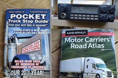
What you'll need: a trucker atlas, a truck stop book, a CB, a few notebooks and Google Maps. I often wonder how many drivers keep a Rand McNally atlas in the truck and know how to use it. Some use it to its fullest. With the wealth of info it contains, it should be your best friend.
When looking at the atlas, I would always plan a run at 60 mph with a goal of 600 miles per day.
Why? To account for traffic. Some days I might get 700 and others only 500, so I would plan out for those options, too.
Most states (but not all) match mile markers with exit numbers, so you can easily plan out how far you want to run that day.
 Let's uses western Kansas as an example. Mile markers, the little green blocks, go from west to east and south to north. So, if I started my run at the state line going east, it's easy to tell, based on the map, how far I think I can drive that day. Note: There is one big difference between interstates and U.S. routes -- interstates run small to big numbers from west to east and south to north, and U.S. routes are the opposite. If you know this, you can easily trip plan your miles for any given day.


Next, out comes the pocket truck stop guide. This is a must-have because it shows the size of truck stops so you can better select your best option. If your route takes you through a big city and you think you may be low on hours when you get there, plan to stop short of it, as you're not likely find parking later in the day. Its just not worth the risk.
Now, for the CB.
Aside from traffic updates you might get over a CB radio, sometimes the best-laid plans can go south. Maybe the truck stop or rest area you were aiming for is full. Many of us have found little out-of-the-way places you can sneak a truck into that few know about. The CB radio is where to gain that information.
I've been saved many a time by a tip from a driver, so keep your radios on.
OK, now on to Google Maps (not GPS).
As we know, physical paper maps often don't go into great enough detail, so if your stop is in a town or city this app will save your bacon. If you already use it, great. If not, download it.
Using Google Maps is all about dialing in on things like crossroads and traffic lights or exits that might not be clear on the map. Study the detailed, three dimensional maps and satellite pictures on Google Maps, but don't trust its directions or use it as a substitute for your own critical thinking.
Is there a median that might dictate which way you come at your location? What about the specific location of a building within a complex? These are all the things you need to figure out long before you arrive there. If it took me three days to get close to a stop, I'd spend how ever much time needed the night before to dial all that in and write it down. That time spent is well made up when you roll straight into where you need to be. It's not easy, but of all the skills needed in this profession, this is perhaps the most important one of all. Without being good at trip planning, you'll never be a top-shelf driver.
Now, the notebooks.
Two things I've always done is write down on a note pad every single detail of a run to include fuel stops and parking options with exit numbers and mile markers and landmarks along the way, such as crossed interstates or other U.S. routes. Also, I note the towns along the way. This helps me gauge where I'm at, and how much further I plan to go. It's all there at a glance.
My ace in the hole, though, was a separate book I kept for exit ramps. In the states that would allow parking on a ramp, I kept my head on a swivel looking for good ramps. I would log them by state, route number, exit number and direction.
It came in very handy late at night when you're in a bind or just don't want to fight a truck stop or packed rest area.
Navigating Canada
Most U.S. drivers will never go there, as the Canadian drivers will pick up loads here and run them north of the border, but a run there requires a higher level of trip planning.
My experience is limited to Ontario and Quebec, so I can only speak to those provinces. My loads there were almost always in some remote location, so I learned to do three things.
First is fuel here in the U.S.A. Petrol Canada rules the roost up North. There are no Pilots, Love's or TAs in that region, and only a small handful of Flying Js.
Next I would double down on Google Maps here before crossing. Signage is different there, so invest the extra time on this. And lastly, get your hands on some old-school, paper, fold-out maps. If you're Ontario bound you will, for sure, wind up on the 401 at some point.
The service plazas there are called "on routes." Most are small, so don't count on them much for parking, but at the larger info centers you can get a free map. Don't lose it!
Quebec is tougher in that regard, but you can find them. If you can find some of their plastic money, that will help, too. They accept U.S. dollars as a general rule but not at the exchange rate. There is no ramp parking allowed that I've ever seen, so you will have to make good use of the truck stop book or talk to the shipper/receiver about overnight parking.
Obey the 100-km speed limit. If you're Quebec-bound, know that you will not find many signs in English. We are pushing English language proficiency here, so take the time to learn a few key French words found on signage there like est, quest, nord, sud (the cardinal directions) and work-zone signs.
In conclusion, drivers, if you invest the extra time to do a solid trip plan it will pay dividends in much less stress and more efficient, productive runs. Drive safe!