Early season winter storm expected across parts of ID, MT, WY, and the Dakotas with widespread accumulating snow. Get the latest at https://t.co/p0EOS74Xus #WeatherReady pic.twitter.com/VFcQpCduvL
— National Weather Service (@NWS) October 8, 2019
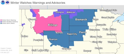
The National Weather Service is forecasting another winter-like storm for much of the northern portion of the country for the next several days.
A winter storm warning has been posted for parts of Montana and Idaho from Wednesday afternoon through Thursday evening. A winter storm watch is in effect for other parts of those states and northern Colorado during that same period. Snowfall is expected from Denver to northern Minnesota and to Billings, Montana.
The Weather Channel is forecasting between a foot and 18 inches of some for some parts of the storm area. Expected snowfall includes:
- 12 to 18 inches in an area including Helena and Billings, Montana; and Jackson, Wyoming, and border sections of Idaho
- 8 to 12 inches in parts of North Dakota
- 5 to 8 inches in parts of North Dakota and South Dakota
- 3 to 5 inches in parts of both Dakotas, northern Minnesota, eastern Wyoming, northwest Nebraska and parts of Colorado
- 1 to 3 inches in northeast Colorado and much of Nebraska
- under an inch across some of these areas and even into northwest Kansas
The snow is expected to be accompanied by much colder than normal temperatures, according to the weather service.
Billings, Montana, is expected to have a high near 70 on Tuesday, before temperatures plummet into the 20s with an AccuWeather RealFeel® Temperature in the teens as snow falls at night: https://t.co/zOVjkU4n8y pic.twitter.com/dzXlqgbX1Z
— AccuWeather (@accuweather) October 8, 2019