UPDATE Tuesday, 5:45 p.m.: Massachusetts officials note a travel ban would lift at midnight Tuesday as storm moves out.
Meanwhile, in Maine, two drivers at the Kennebunk service posted to Overdrive’s Facebook page with views from the state that saw perhaps the largest portion of the storm.
Here’s Corey Kiesman and Tom Crawford Jr.‘s views from Maine:
 “No trucking for me today. The place I’m going to is closed anyway.” —Corey Kiesman
 “Receiver will have to wait till tomorrow for delivery.” –Tom Crawford Jr.
N.J.'s @GovChristie lifted travel ban as snow passes via @njdotcom #blizzardof2015 #Juno #NJ https://t.co/V2GgGFoLkN pic.twitter.com/Bw7WWmmHEo
— Kathleen DeCosmo (@katiesheadesign) January 27, 2015
UPDATE Tuesday, 8:30 a.m. Central: Travel bans formerly in place with the expectation of blizzard conditions Monday were reported lifted in parts of New Jersey, New York and Connecticut as Winter Storm Juno passed and moved North the morning of Tuesday, Jan. 27.
Tractor/trailer ban in NY as of 4 p.m. see details https://t.co/L3wohUh9bK pic.twitter.com/20rROo1eBT
— Truckers News (@truckersnews) January 26, 2015
UPDATE late Monday afternoon, January 26: Overdrive sister magazine Truckers News reports that New York State Governor Cuomo issued a tractor-trailer ban on state highways effective the afternoon of January 26 and, according to the Syracuse.com news site, to be in effect through 11 a.m. Tuesday, January 27.
New York joined Massachusetts, whose governor issued a travel ban effective at midnight Tuesday, to be lifted on a county by county basis through the day tomorrow.
Other New England states likewise followed suit:
There is a travel ban for the entire state of #CT beginning at 9pm tonight. Make sure your pets have food & any medicine they need. #Juno
— ASPCA (@ASPCA) January 26, 2015
NY, NJ and MA have declared states of emergency; a travel ban in CT takes effect at 9 pm ET. #Juno #Blizzard2015
— Andrew Peng (@TheAPJournalist) January 26, 2015
Gov. Raimondo declares State of Emergency – travel ban at Midnight tonight https://t.co/v840ruVHcm #CW28 #Blizzard2015 #Juno
— CW28Providence (@CW28Providence) January 26, 2015
Original dispatch follows:
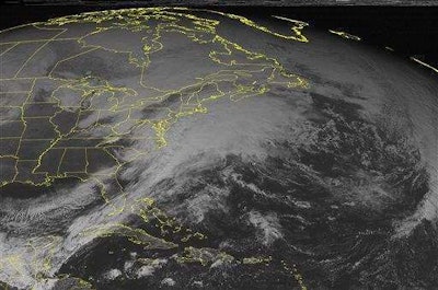
Today's Weather: Major #noreaster expected to bring hvy snow, blizzard conditions to Northeast https://t.co/vT29JlRubR pic.twitter.com/lY3jv6Vb40
— NWS (@NWS) January 26, 2015
The National Weather Service tweeted the above photos this morning as news reports around the nation were dominated by forecasts for what commentators are calling Winter Storm Juno, a nor’easter bearing down on New England and upper Mid-Atlantic states.

“Blizzard warnings are in effect for the coastal areas of New Jersey to Maine,” including some heavily trafficked truck routes, warned the National Weather Service. “Winter storm watches and warnings are in effect for portions of higher elevations of West Virginia and Maryland, in addition to Eastern Maryland and Delaware into Maine.”
The NWS noted a “new surface low will develop along the North Carolina / Southeast Virginia coastline” this morning and “intensify rapidly as it moves Northeastward off the Mid-Atlantic coast. From there, it will move along the Northeast coastline from Monday night and into Tuesday” bringing with it snow totals of up three feet from New York City northward, some forecasters are predicting, more or less in spots.
Travel advisories extended into “portions of the Ohio Valley, the Mid-Atlantic [region] and the Southern Appalachians in Georgia and North Carolina.”
Find weather updates at Weather.gov and Weather.com.
Our LIVE blog is up & running, follow it for latest weather information as #Juno strengthens: https://t.co/OJuXrkk8sq pic.twitter.com/g4QvPgXUTo
— The Weather Channel (@weatherchannel) January 26, 2015
#Lightning strikes slowly starting to pick up offshore. Fasten your seat belts, folks. Here we go. #Juno pic.twitter.com/ZbF2yqmHgi
— Jonathan Erdman (@wxjerdman) January 26, 2015
Up to 2 FEET+ of #SNOW possible for parts of the #Northeast Mon.-Wed. #Juno #BLIZZARDof2015 https://t.co/xy1j7ogu4H pic.twitter.com/GIgLp0HnSV
— The Weather Channel (@weatherchannel) January 26, 2015